 Envirocon’s ultimate goal of increased productivity and safe, high-quality performance drives the organization’s consistent efforts towards operational excellence. Envirocon’s commitment to embrace new technology in executing challenging environmental remediation and demolition projects lead to the recent purchase of an Real Time Kinematic (RTK) Photogrammetric Unmanned Aerial Vehicle (UAV) for surveying.
The UAV weighs less than two pounds and uses a high-resolution digital camera to capture imagery of virtually unlimited acres. This tool provides access to areas previously unavailable due to cost or location constraints. Multiple real-time photos of the site are stitched by software into one large photo. The photo and data collected are overlaid into a CAD drawing to help CAD technicians develop models of the earth’s surface. Other features, such as an outline of a building or the outline of stockpiles, can also be identified. This new technology has several advantages, including speed, accuracy, and the ability to capture real-time photos of the site.
FAA requirements require operators to obtain a pilot’s license, along with an FAA 333 exemption to operate the UAV. Envirocon’s lead surveyor, Mike Shaylor has completed all the necessary licensing and training. He operates the UAV as well as processes the photos and data.
Special software is used to preplan flights, control the UAV, and download post-flight data. In order to fly the UAV, first the flight path is programmed prior to the field flight. The software tests the flight for potential obstacles and crashes. An RTK base station is set up on a known state plane coordinate in the area for the flight. The RTK coordinate adjustment is routed through the computer, making any necessary corrections to the flight plan, and then uploaded to the UAV. Once the transfer is complete, the UAV is turned on and tossed into the air to fly the pre-programmed mission. Based on the flight path, the UAV automatically lands upon fulfillment of its task. The information is then downloaded and a mapping tool is used to process post-flight data and create deliverables that can be used with CAD design software and shared with our clients.
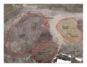
On a recent remediation project at a former lumber mill site in Bonner, Montana, Envirocon was able to successfully set up, fly the 5 acre site and collect over 21,630 data points in under one hour. Traditional survey methods would take many hours of field data collection due to the many features over a large area. Because there are many thousands of points developed from the UAV photogrammetry, the resulting modeled surface is more representative of the true surface; therefore, volumetric calculations are more representative of fact, with typical accuracies at +/- 3 cm (approximately). In one area, due to the depth of the excavation, collecting data using traditional methods posed safety risks; using the UAV, we were able to capture accurate quantity and contours safely.
This new tool provides a cost-effective solution for quality data collection and real-time mapping on our project sites, thus allowing project teams to make real-time decisions based on current and changing site conditions. Although the UAV has several advantages, there are also limitations of use, including densely vegetated areas and homogeneous areas where this tool cannot accurately collect data. Envirocon is committed to deploying and engaging the latest technical innovations in support of our projects, ultimately providing value to our clients.