Envirocon’s in-house surveying team is made up of Subject Matter Experts, licensed Surveyors, and CAD specialists, with field support from trained and experienced Field Engineers and Coordinators. Together, our team uses multiple surveying tools to produce volumes, layouts, as-builts, and Quality Control documents on our projects. This offers our clients greater execution precision, minimizing rework and increasing the safety, efficiency, and quality of our project delivery services.
Much of Envirocon’s surveying services center on the use of Real Time Kinematic (RTK) satellite navigation, a technique to identify a real-time, precision position at a roving GPS device. Based on RTK, we offer our clients field surveying services using tools like GPS-equipped heavy machinery for precise, accurate excavations; Unmanned Aerial Vehicles (UAVs) for topographic surveying and point mapping; and DredgePack systems to guide mechanical and hydraulic dredges. RTK GPS equipment delivers centimeter-level positional accuracy to produce results that are difficult to achieve with conventional, non-equipped machinery.
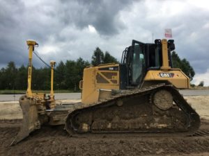
Our GPS equipment fleet relies on a carefully setup and calibrated RTK base station to send centimeter positional corrections. This correction is transmitted to the roving device installed on heavy equipment via radio where it is computed and applied. This information is then used by equipment operators for precision cuts based on surveying control points set up at the outset of the project to effectively achieve design lines and grades.
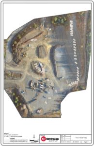 Envirocon’s RTK UAV provides additional surveying benefits and services for our clients. The UAV can fly Envirocon’s project sites and deliver incredibly accurate imaging used to generate topographic surveying documents and volumetric calculations. Using a suite of software, this imaging information is compiled, processed, scrubbed, and exported into AutoCAD Civil 3D to generate final drawings with centimeter-level positional accuracy. These drawings are then used for work plans, Quality Control, as-builts, and often design submittals for client, regulatory, and stakeholder approval. Use of the UAV for project surveying can drastically increase project safety by removing ground-based personnel from often steep or dangerous areas, and reduce the time and costs required to manually survey a site.
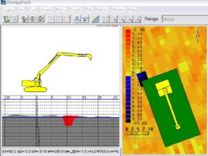
For mechanical and hydraulic dredging projects, Envirocon’s use of RTK-based DredgePack software delivers similar results as our land-based GPS operations. DredgePack is designed specifically for dredging applications and operates in a similar manner as traditional RTK GPS systems. Using the same base station and roving devices, surveyors use established control points derived from bathymetric (underwater topography) surveys. Equipment operators use in-cab DredgePack software to perform precision dredge cuts and monitor real-time results, ensuring that excavations are made per design specifications and bathymetric information. This approach to dredging dramatically decreases rework associated with inaccurate excavations so that projects are delivered in the most efficient and cost-effective manner.
Using RTK GPS equipment, UAV surveying and mapping, and specialized GPS dredging software, Envirocon can increase the safety, efficiency, and accuracy of our project delivery services for our clients. Our in-house surveying tools, procedures, and skilled personnel combine to provide reliable, high quality, and cost effective solutions to our clients’ complex environmental projects.